Guye Peak South Gully
Friends: SteveLocation: Guye Peak
Elevation gain: 0m = 0m
Guye Peak has been a popular climb for a long time. It rises only 2000 feet above Snoqualmie Pass, but has a very dramatic West Face for local skiers to contemplate as they ride the chairlifts. Beckey's Bible lists 11 different routes, not including minor variations on the rock climbs. Hikers can choose the North Route, but will probably be content with the South Summit, since exposed scrambling is required to tag the Middle and North Summits. In January, Steve, Peter, Chris K. and I took this route in ridiculous snow conditions, with the booming of avalanches and avalanche control cannons echoing across the valley. Routes on the steep West Face look intriguing, especially to Peter. He has a season pass at the Alpental ski area and much occasion to admire the face. I've been disturbed by Beckey's comment that "much of the steep rock on the S and W faces is brittle, therefore treacherous to the climber." Another choice comment is that "the rock is general solid (although friable)." What am I supposed to do with that remark?!? But that is a story for another day, when he'll surely lure me up!
Today, Steve and I found ourselves at the base of the South Rib, our visions of climbing Chair Peak deteriorating with the weather. Had we come a week earlier, we would have found consolidated snow there, with a strong crust from clear nights. It snowed on Thursday, and fresh avalanches littered the basins. We retreated from the bench above Source Lake, wanting to try something else while we still had a full day.
At the rib, we approached the rock, which merely looked wet. A cold fog had come in as we hiked up, and within an hour it would be snowing. But the rock was covered in a thin layer of ice. I hit a boulder with my ax and saw cracks appear on the almost invisible layer of slippery ice, realizing I was seeing verglas for the first time. Gaining 6 feet of elevation on that kind of ground was more excitement than we wanted. We knew there was a gully route just around the corner to the right, and decided to try that, hoping for snow.
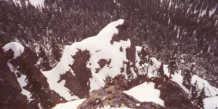
This is taken from the rappel notch. Another party went down the steep gully below the ridge.
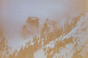
Very gloomy weather approaching Chair Peak
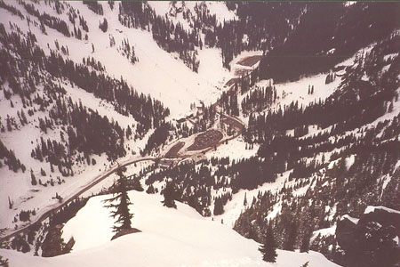
Ah, look at the commercial recreationists!
So we headed up a snow gully for several hundred feet, working our way over or around occasional tree or rock steps. Occasionally, the gully ended in a cliff, sending us to the right where a continuation always appeared. At one confusing point we looked around in the mist, objects further than 20 feet were hard to make out. I spied a solitary humanoid figure in trees to the right of our gully. He appeared to be looking at us, and standing completely still. "Hello!" I said. Just when I decided I was imagining the figure, it moved our way. This fellow and a companion would follow Steve and I for most of the route.
Steve kicked steps up a particularly steep section, and we noticed rappel slings around trees on the side of the gully every 100 feet or so. We came to a dead end, and he led up to a ledge at the base of a cliff. Around a blind corner, Steve had taken off his pack to squeeze through a hole between tree and cliff (going around the tree was not an option unroped!). I followed, then we crossed a steep gully. While Steve worked on dubious snow to escape to the right, I went higher looking for a ledge system to take us out. Again, verglas proved too intimidating, and Steve had gotten past a tricky moat, so I went back and followed his excellent trail. Reached a low angle forested patch, we took a break. We thought the pair below had turned around at the intimidating tree/rock hole, but they rested and continued, later sending me email after seeing this page. They enjoyed the climb as much as we did. I wish I had taken some pictures at that point, because the exposure and scenery were excellent. All near-vertical snowy cliffs pointing down into the mist, with a couple of figures in the colouir. You'll just have to climb the route...
We had easy walking for a while, then an impasse. We climbed leftward to a hanging gully, but I didn't want to cross the thin snow over slabs and vegetation to get to a lower angle snow slope. A fall would take you right over the cliff 10 feet below. Instead, we took a rocky ledge to a thin colouir with a tree at the base. Climbing up the colouir, we were mere feet from an exit onto easy slopes, but the exit was guarded by icy rock that required protection. Steve hunted for another way, but only came to a more dangerous point. So we backed down to belay at the tree. I led off, placing a nut at the crux, then escaping to snow slopes. I decided to run the rope out, using a sling around a tree higher up. Finally, I reached a tree belay at the point that the South Rib and South Gully routes meet up. I could see over to the Alpental parking lot again. Steve came up, then took off for a lead on steep snow to a rock step that gained the ridge crest. After this exciting bit, he reached low angle slopes, and belayed me up. We walked to the summit, having really enjoyed this climb. We had local views of the Alpental valley, and the tiny flea-like skiers.
Now, we had to climb down a snow slope then belay a pitch up to the middle summit. Steve got this lead, finding the rock blocky and fun. Thankfully, it wasn't iced up. He placed one camming device on the pitch, then ran the rope out to a bucket belay in the snow on the middle summit. From here, I climbed down on snow to a rap anchor at a tree. Here, we rappelled into the gully below the north summit. Actually, Steve climbed down on belay, then I rappelled. By the time I pulled the ropes, Steve had kicked steps up the 50 degree snow gully to just below the north summit. We tagged this summit, then took long strides down towards the Cave Ridge saddle. Another party had come behind us, and descended the steep gully to the Commonwealth Basin. We reached the saddle, and decided to go straight to the Alpental parking lot. We had some tracks to follow, and this route was not as steep as I thought it would be. It was much quicker than going to Commonwealth Basin. Of course, we had to walk the road for a mile.
The climb took us most of a day, but I expect that in good snow conditions, or with previous steps to follow, this could be a great half-day outing. I'd like to go back in early May and climb the South Rib. Thanks to Steve for a great climb!